
How Tank Locating and Mapping Works for Septic Owners
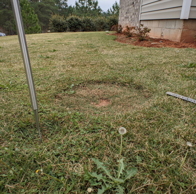
Most septic tanks are invisible from the surface, and the paperwork that showed where they sit rarely survives a change of ownership. Nobody handed you a site plan at closing. The previous owner is unreachable, the county file is thin, and the yard gives up no clues beyond a faint dip in the grass near the fence line. This is one of the most common calls a septic crew gets, and it has almost nothing to do with the tank being broken. It's about not knowing where it is.
A buried tank doesn't announce itself. Lids get covered with sod, risers get mowed over or removed, and paperwork from a system installed decades ago often didn't survive a few changes of ownership. Locating and mapping solves that problem before it turns into a bigger one, whether the goal is scheduling routine pumping, planning a remodel, or figuring out where a drain field starts and ends.
A Tank Goes Missing on Paper Long Before It Goes Missing on the Ground
Septic systems are built once and then mostly ignored for years at a stretch. That's by design. A properly functioning tank doesn't need attention between pumpings, so there's no reason for a homeowner to think about where it sits, let alone photograph it or mark it on a survey. Multiply that by a sale or two, a few landscaping projects, and a couple of decades, and the physical record disappears even when the tank itself is fine.
Permit records fill part of that gap, but not all of it. Older systems, especially ones installed before certain recordkeeping requirements existed, may have thin files or none at all. Even when a permit exists, it typically shows an approximate layout rather than exact coordinates, and yards get reshaped by additions, fences, and regrading in ways that make an old sketch hard to trust. A locate follows a defined process, though, not a hunch. It combines a few reliable techniques to narrow the search from "somewhere in the yard" to a marked spot you can plan around.
Probing Still Works Because Soil Tells on Itself
Before any electronics come out, a technician often starts with a metal probe rod, walking a grid pattern in the area where the tank is expected to be based on the house's plumbing layout and any visible clues like a slight depression, a patch of grass that grows differently, or the angle of the sewer line leaving the foundation. The probe is pushed into the soil at intervals, and a trained hand can feel the difference between undisturbed native soil and the looser backfill that was used when the tank was buried.
This works because installation always disturbs the ground. Even a tank buried forty years ago left behind a column of soil that was dug out, mixed, and put back, and that column stays looser and easier to probe than soil that was never touched. It's not unlike knowing where a garden bed used to be years after the plants are gone, because the soil underneath still feels different from the lawn around it. Probing alone can miss a target if the search area is too broad, which is why it's usually paired with other methods rather than used on its own.
Electronic Locating Tools Confirm What Probing Suggests
Once probing narrows the search, electronic locating equipment pins the tank down more precisely. One common method involves feeding a small transmitting device through a cleanout or access point into the pipe leading to the tank, then using a receiver above ground to follow the signal as it travels underground. The receiver picks up the transmitter's location and depth, allowing a technician to trace the exact path of the line and mark where it terminates at the tank.
Metal detectors and pipe locators serve a similar purpose on tanks or components that contain metal, such as certain lids, risers, or fittings. Ground-penetrating equipment can also help identify a change in subsurface density consistent with a buried tank, though this works best combined with the other approaches rather than as a standalone method. None of these tools replace the knowledge of someone who has done this work for years and knows how to read what the equipment is telling them, but they take a lot of the uncertainty out of digging in the wrong spot.
If your home has an accessible cleanout near the foundation, point it out before the locate starts. It often gives the crew a faster starting point for tracing the line to the tank.
Tracing From Known Fixtures Narrows the Search Fast
Every septic system starts at the house. The main sewer line leaves the foundation at a predictable point, usually where the plumbing stack and main drain converge, and runs in a fairly direct path toward the tank. A technician familiar with typical installation patterns can often substantially narrow the likely tank location by following the presumed path of that line from its exit point, factoring in the house layout and any visible venting or cleanout access along the way.
Interior clues help too. Where the main drain exits the basement or crawl space, and the general direction it runs, gives a starting bearing for the search outside. Combined with the age and style of the house, which often hints at when the system was installed and what layout was standard at the time, tracing from known fixtures turns a wide search area into a focused one before probing or electronic tools ever touch the ground.
Historical Permit Records Fill in What the Yard Can't Show
County or local health department files sometimes hold a permit sketch, an as-built diagram, or an inspection report from when the system was installed or last serviced. These records vary widely in quality and completeness depending on when the system was installed and how the paperwork was handled at the time, but even a rough sketch showing the tank's approximate distance from the house or a property line gives the locate a head start.
Records searches work best paired with fieldwork rather than in place of it. A forty-year-old permit sketch might list measurements from a fence or shed that no longer exists, or a distance that was estimated rather than surveyed. Treating those records as a starting reference, then confirming the actual location with probing and electronic tools, produces a result you can rely on.
A Completed Map Turns Guesswork Into a Plan
Once a tank and its components are located, marking and mapping the layout make the work useful going forward. A typical map records the tank's location relative to fixed points such as the house corners or a property line, the depth of the lid or risers, the path of the inlet and outlet lines, and the location of the drain field. Some setups include spray paint or flags on the surface for immediate use, along with a written or digital record kept for later reference.
That record does three things well. It means the next pumping visit doesn't require another search, since the crew already knows exactly where to dig or where risers are accessible. It protects the system during construction because contractors performing excavation for a pool, addition, driveway, or utility line can route around the tank and drain field instead of risking a direct hit that would damage the system. And it supports planning for drain field repair or replacement down the road, since knowing the field's exact footprint tells you how much undisturbed ground is available for a repair or replacement field without disturbing the septic tank itself.
Never attempt to probe for or dig near a suspected tank location without a professional locate first. Striking a buried tank, riser, or line can cause structural damage, a sewage release, or a safety hazard, and excavation near a septic system carries real risk without the right equipment and training.
Why Locating Matters More in Certain Yards
Not every property carries the same risk if a tank's location is unknown. A property with no drain-field footprint on record needs a full search before any planning can happen, since there's no distance or depth to confirm once digging starts nearby. Homes with excavation already scheduled, such as a pool, addition, driveway, or utility trench, carry greater urgency because equipment moving dirt near an unmarked tank or field risks a direct hit that an accurate map would have prevented. A site with a high volume of use, such as an RV park or campground, needs the same kind of clear documentation, just multiplied across more fixtures and often a larger, more complex system layout.
Protecting groundwater is part of why an accurate map matters. A drain field that's improperly sited or damaged during nearby digging can affect water quality, so having a written layout on hand gives you and any contractor working on the property a clear picture of where the system's boundaries actually are before any equipment moves dirt.
What to Expect When You Schedule a Locate
A typical visit starts with a conversation about what's already known: any records you have, roughly when the system was installed, and where the plumbing fixtures are located inside the house. From there, the technician works through probing, tracing, and electronic equipment as needed until the tank, lids, and drain field boundaries are confirmed. Depending on the property and how much documentation already exists, a locate can be a fairly quick visit or a more involved search across a larger yard.
Once the layout is confirmed, ask for a copy of the map or notes for your own records, whether that's a simple sketch with measurements or a more detailed written report. Keeping that record with your home's paperwork means the next owner, contractor, or service crew won't have to start from zero the way you may have had to.
Frequently Asked Questions
Tracing and electronic equipment can usually confirm a tank's exact position and depth without breaking up a hard surface first. Once that spot is marked, a technician can walk through what access would involve, whether that means cutting a section of concrete, working around the structure, or planning access from an adjacent part of the yard.
In most cases, yes. Probing, electronic tracing, and records review are designed to confirm a tank's location before any digging happens, so the actual excavation, if needed at all, is limited to accessing lids or risers once the spot is confirmed.
Locating focuses on position, not condition. A separate inspection is needed to evaluate the tank's structural state, sludge and scum levels, or whether the drain field is absorbing properly.
Some older systems or additions were installed off the standard path from the house, which is exactly why tracing from known fixtures and probing a wider grid matters. Relying only on assumptions about typical placement can send a search in the wrong direction.
Many buyers request one as part of due diligence, since it confirms the tank and drain field exist where records suggest and gives you a written starting point instead of inheriting the same records gap the previous owner may have had.
Yes. Once a locate confirms exactly where the lid sits, risers can typically be installed to bring access up to grade, so future pumping or inspection visits don't require digging to find the lid again.
Schedule a tank locate — get your septic system mapped before your next project or pumping visit. Heavy Duty Pumping & Septic LLC serves Lucedale, Leakesville, Hurley, MS. Call (601) 804-2230.
